
Voicemap

Old Amsterdam - East.
A Walking Tour of old Amsterdam's East Side.Roam the canals and docklands of old Amsterdam and the Jewish district with this Voicemap audio tour.
Below, images used in or related to the walk.
The Return to Amsterdam of the Second Expedition to the East Indies, Hendrik Cornelisz Vroom, 1599 (Rijksmuseum)
The start of Dutch involvement in trade with the East.
Click on image for full size painting (4.2 MB). Opens in new tab.

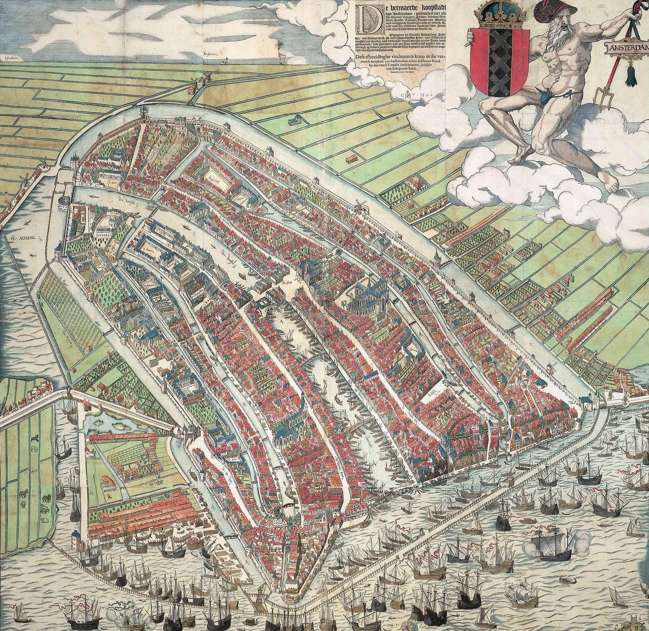
Amsterdam map by Cornelis Anthonisz.1544. Cutout of the Lastage maritime district.
Click on image for full size map on Wikipedia (1.7 MB). Opens in new tab.
Reinier Nooms 1652-54. Embarking at Montelbaanstower.
Rijksmuseum RPP-OB-20.533.
Click on image for full size map (4.90 MB). Opens in new tab.

Jewish people who lived on the different floors of Zandstraat 11, Amsterdam.
Click on image for full size (1 MB). Opens in new tab.
More information on joodsmonument.nl.

Freight barges on the Dutch canals were generally towed, by horses or people. By children as well. Like on the photos of the family business below, taken as late as the 1930-ies !

One of the many vanished streets in the Jewish district.
Photo: Amsterdam City Archives.

Cutout of Amsterdam map 1688, by Frederik de Wit.
Click on image for full size map (5.94 MB) on Wikipedia.

Plantage Muidergracht c.1670. In the distance the tower of the Southern Church. On the right the Portuguese Synagogue. Nowadays the canal is a busy street.

Rijksmuseum SK-A-3738.
Click on image for full size painting (4.80 MB). Opens in new tab.

"Hollandic Theatre" - Hollandsche Schouwburg, originally named Artis-Schouwburg. Foto by Andreas Theodorus Rooswinkel - date 1892-1894.
In WWII the Nazi occupiers used the building as a deportation center during the Holocaust.
(Image: Amsterdam City Archives)
 Below: The ruined Hollandsche Schouwburg in 1962, a memorial to the Dutch victims of the Holocaust.
Currently in the middle of a renovation project, the memorial is expected to reopen in 2024.
(Image: Amsterdam City Archives)

Navy warehouse 1726 by J. Mulder.
Left of the warehouse navy shipyards and workshops.

Mock battle on the IJ in honour of the Muscovite legation 1697.
Under the red arrow the Russian yacht, and tsar Peter the Great in red coat.
Painting by Abraham Storck. Amsterdam Museum SA 22993
Click on image for full size painting (0.55 MB). Opens in new tab.

Cutout of Amsterdam map 1688, by Frederik de Wit.
Click on image for full size map (5.94 MB) on Wikipedia.
Amsterdam map 1688, by Frederik de Wit.
Click on image for full size map (5.94 MB) on Wikipedia.